


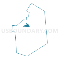
Voting District 020003, Lewis County, New York
About
Outline

Summary
| Unique Area Identifier | 629528 |
| Name | Voting District 020003 |
| County | Lewis County |
| State | New York |
| Area (square miles) | 10.72 |
| Land Area (square miles) | 10.65 |
| Water Area (square miles) | 0.07 |
| % of Land Area | 99.38 |
| % of Water Area | 0.62 |
| Latitude of the Internal Point | 43.88459920 |
| Longtitude of the Internal Point | -75.52707350 |
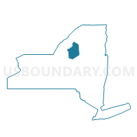
Maps

Graphs
Select a template below for downloading or customizing gragh for Voting District 020003, Lewis County, New York


Neighbors
Neighoring Voting District (by Name) Neighboring Voting District on the Map
- Voting District 010001, Lewis County, NY
- Voting District 020001, Lewis County, NY
- Voting District 020002, Lewis County, NY
- Voting District 050001, Lewis County, NY
- Voting District 080003, Lewis County, NY
- Voting District 080006, Lewis County, NY
- Voting District 120001 120002, Lewis County, NY
Top 10 Neighboring County Subdivision (by Population) Neighboring County Subdivision on the Map
- Lowville town, Lewis County, NY (4,982)
- Croghan town, Lewis County, NY (3,093)
- Denmark town, Lewis County, NY (2,860)
- New Bremen town, Lewis County, NY (2,706)
- Harrisburg town, Lewis County, NY (437)
Top 10 Neighboring Place (by Population) Neighboring Place on the Map
Top 10 Neighboring Unified School District (by Population) Neighboring Unified School District on the Map
- Lowville Academy and Central School District, NY (8,762)
- Beaver River Central School District, NY (5,548)
- Copenhagen Central School District, NY (2,872)